California Rethinks Firefighting Tactics, Evacuation Routes for Future Wildfires (#GotBitcoin?)
The Camp Fire, California’s deadliest and most destructive wildfire, has left communities around the state reevaluating everything from their evacuation routes to communications systems. California Rethinks Firefighting Tactics, Evacuation Routes for Future Wildfires (#GotBitcoin?)
James Gore, a supervisor in Sonoma County, which was ravaged by multiple fires in October 2017, said 13 communities in high-risk areas have put together maps, and residents are now practicing new escape routes more regularly.
“Everybody is playing catch-up. Everybody is trying to address the new normal,” said Mr. Gore, who is leading the statewide county association’s effort to help others better prepare.
Seven of California’s 20 most destructive wildfires and five of its deadliest have occurred in just the last 13 months. The Tubbs Fire that hit Sonoma and Napa Counties last year killed 22 people; it was considered the state’s most destructive before the Camp Fire ignited. The latter has killed at least 88 people and burned roughly 18,800 structures.
Cal-Fire, the state fire-protection agency, has classified more than 180 locales in 31 counties—from Siskiyou on the state’s northern border to San Diego to the south—as being in the most hazardous fire zones. Paradise is on the list, as are communities like Berkeley, Oakland, Los Angeles, Malibu, Monterey, Santa Rosa and Thousand Oaks.
“There is a whole new focus,” said Graham Knaus, the executive director of the California State Association of Counties. “When you have wildfires moving 80 football fields per minute…it causes a full revaluation on how best to move forward.”
Rebecca August, a public lands advocate with Los Padres ForestWatch, a nonprofit, attended a hearing on California’s emergency-warning system earlier this week. She said attendees discussed deploying fire-safe shelters in area that might be hard to evacuate.
“I hadn’t heard people talking about that before,” she said.
Citizen groups are also taking action. Priscilla Abercrombie, who lives on Fitch Mountain outside of Healdsburg, in Sonoma, is part of a group that has put together a phone tree residents can use to help evacuate if a fire or other natural disaster strikes. Healdsburg firefighters debriefed her group this week about the recent fires.
“People are really motivated,” she said. “The take-home message is to know who your neighbor is and ways to get off the mountain, and have a plan, and have your stuff ready.”
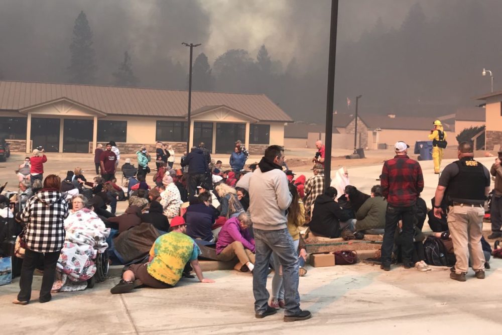
Perhaps the most frightening aspect of the Camp Fire that destroyed Paradise, a former Gold Rush town of 26,000, was how quickly it moved. The fire was first noticed before 7:00 a.m on Nov. 8, and an hour later the entire town was under an evacuation order. Two hours after sundown, the community was all but wiped out.
“We had planned for a wildfire. What we got was a hydrogen bomb,” said Jim Broshears, Paradise’s emergency-operations center coordinator.
After a particularly bad fire season in 2008 in the area, a grand jury report laid out critical shortcomings in preparedness. The report concluded that additional evacuation routes were necessary after thick smoke forced three main roads out of Paradise to close, and left a fourth choked with a single lane of traffic.
One new paved evacuation road has been built since then, a northbound route that took 10 years to complete. Kim K. Yamaguchi, who lobbied for the project when he was on the Butte County Board of Supervisors, said he has received thank-you messages from people who used it to escape the Camp Fire. “Touched my heart,” he said.
Officials say a plan put in place after 2008 to evacuate Paradise in phases to better control traffic flows didn’t work well because embers sparked hundreds of spot fires across the town, forcing evacuation orders to be issued in rapid succession.
Officials say it would take much more than a few million dollars to finance the road projects rural communities like Paradise need to evacuate thousands of people quickly.
Phil John is chairman of the Paradise Ridge Fire Safe Council, which has tried for years to advise residents how to create defensible space around their homes and what to take with them when they evacuate.
After the deadly and fast-moving Tubbs Fire decimated large parts of Santa Rosa last year, Mr. John said, he reworked his group’s safety presentations to put even more emphasis on how to evacuate quickly.
“My guts are tore up because I gave my whole life to teach people what to do, and it just didn’t work,” he said. “There’s people that are dead right now because we didn’t get to them, and I have to live with that.”
Updated: 9-17-2020
A California Town’s Fire-Protection Plans Hit Red Tape, Then The Flames Came
North Complex fire hit Berry Creek just as work was to start on forest-thinning projects.
BERRY CREEK, Calif.—As the smoke from the nearby fire-devastated town of Paradise cleared in 2018, local officials were trying to gain approval of forest-thinning projects to help this mountain community avoid a similar fate.
Nearly two years after they first applied for approval from the state of California, the contract for one of the projects went out for bidding on Sept. 4. At the same time, work was about to start on the other after a monthslong wait caused in part by the coronavirus pandemic.
Then just four days later, the North Complex fire roared through this community of 2,500, wiping out most of the homes and leaving at least 10 people dead, more than one-third of the total fatalities from wildfires this year in California.
“I tried to work with anyone who would listen to avoid what happened,” Denise Bethune, a Berry Creek fire safety coordinator, said from her son’s residence in the nearby city of Chico, where she and her husband have been living since their two-bedroom home burned to the ground.
Among the factors contributing to this year’s exceptional wildfire season are climate change, which causes higher temperatures and longer droughts, and poor forest management, according to scientific experts. State and local governments haven’t done enough to thin dry brush and dead trees that burn easily around populated areas, they say.
Few places have felt the consequences more severely than Butte County, a rural area north of Sacramento where 19 large fires have scorched some 400,000 acres since 1999.
Earlier this week, Loren Gill drove into what remains of Berry Creek in an SUV to pick through some of the rubble of what had been a park community center. Nearby lay the ruins of Berry Creek Elementary, with a sign of its mascot, a Native American brave, charred.
“This is unbelievable,” Mr. Gill, 78 years old, said as he drove past dozens of leveled homes, some with only the chimneys still intact. “Just a nightmare.”
The Butte County Fire Safe Council on Oct. 26, 2018, received an $836,365 grant from the California Department of Forestry and Fire Protection, or Cal Fire, to remove trees and brush from 234 acres. The plan was to create fire breaks along two of the main evacuation roads and for a development of homes around Lake Madrone.
Getting approval to spend the money would take almost two years.
While it is impossible to determine how Berry Creek would have fared if the thinning projects had been implemented, local officials said videos of other nearby areas where trees and brush were trimmed showed lower flames that moved slower.
Bald Rock and Rockerfeller roads, the two evacuation routes, now have charred cars and trucks on them. Around Lake Madrone, more than 50 homes were destroyed.
“Somebody dropped the ball,” said Becky North, 41, whose family of four lost the house they lived in since building it in 2011. “I think some homes would have been saved.”
After the Camp Fire destroyed Paradise on Nov. 8, 2018, officials of the Butte County Fire Safe Council—which acts as an umbrella group for fire safety in the area—urged state lawmakers to streamline regulatory red tape.
California Gov. Gavin Newsom responded to the Camp Fire with a slew of directives, including fast-tracked authority for 35 thinning projects to protect 200 communities. Cal Fire said some of the projects had helped slow fires including one in Butte County completed last December.
The Berry Creek projects languished as the Butte County Fire Safe Council struggled to gain landowner approvals for the thinning, a requirement of the California Environmental Quality Act, or CEQA. One of the strictest such laws in the nation, CEQA makes it easy for local residents and interest groups to oppose construction and development projects.
In addition, Cal Fire officials kicked back some of the paperwork filed by the local leaders because it had been improperly formatted. “It’s about lawsuits and if there is not enough information for us to sign we have to ask for more,” said Dave Derby, unit forester for Cal Fire’s Butte area.
A spokesman for Gov. Newsom said his administration is committed to doing more forest-clearing work and that additional projects will be announced in the coming weeks.
To help move the Lake Madrone thinning, which was planned for 54 acres, Butte County Fire Safe Council officials decided to split that environmental review from the one for the evacuation routes because most landowners had signed on, said Calli-Jane DeAnda, executive director of the Butte County Fire Safe Council.
It took 17 months to get the final go ahead from Cal Fire in March. Then a new problem hit: the coronavirus pandemic, which Ms. Bethune said put some of that work on hold.
After approval for the plan to create fire breaks along the evacuation roads came in July, Ms. DeAnda said her group had hoped to start both projects this fall and complete them within a month.
“We were just waiting on the contractor to get started,” she said.
The fire has effectively negated the need for that fuel work, now. The forest of pine and oaks surrounding the town was burned so severely that in some places only skeleton trees are left, devoid of leaves.
Volunteer Fire Chief Reed Rankin, who lost his own home, said all he and other first responders could do was evacuate people ahead of a firestorm driven by 40 miles-per-hour winds.
“We’ve got to rethink how we are going to manage the forests,” said Mr. Rankin, after sifting through the rubble of a destroyed fire station. “I’m still at a loss, still numb.”
Updated: 6-14-2021
Scientists Are Trying To Make California Forests More Fire Resilient
As the threat of wildfire looms, a debate has emerged in the state about the best way to plant trees.
To the untrained eye, the scrubby slope off Wentworth Springs Road in the Eldorado National Forest looks like any other patch of Sierra Nevada ridgetop. Tufted in native shrubs and flecked by darkened pine stumps, it’s part of a 30,000-acre swath of land that was deforested in 2014, when the King Fire tore through 17 miles of canyon in less than six hours.
But Dana Walsh can see what’s unique. On a recent Sunday morning, the USDA Forest Service forester bent over a white flag pinned into the ground to mark a barely-visible seedling. As she points to other seemingly camouflaged baby conifers nearby, what starts to emerge is a subtle pattern she calls cluster planting.
“It’s tough to make out unless you know to look for it,” she said. “But once you see a tree, then you can spot the five or six planted near it. Then there’s nothing. Then there’s another five or six. Then there’s nothing.”
These little trees were placed here under Walsh’s supervision earlier this year, as part of an ongoing replanting of about 8,000 acres of the massive King Fire scar. She designed this area to mimic the gaps of cleared-out vegetation that decades of frequent, low-severity fire—a natural feature of the Sierra Nevada ecosystem—would create in a more mature forest. Emerging science suggests that creating more of that spotty, clustered mosaic in California forests could make them more wildfire-resilient.
“We know one of the problems behind California’s incinerating forests is the increased fuels from years of fire suppression,” said Malcolm North, a research ecologist at the Forest Service’s Pacific Southwest Research Station and professor of forest ecology at the University of California, Davis, referring to the dense overgrowth that results from swiftly stamping out wildfire. “But we’ve also learned that the spatial pattern of trees turns out to make a big difference as well.”
Yet replicating that organic pattern is a relatively new approach to tending these woodlands, and it clashes with a longstanding norm of planting trees individually, at even intervals, in order to maximize growth. That model—sometimes referred to as plantation forestry—is still used by many practitioners in the Forest Service and on private lands. And while planting trees in groups is not a totally foreign concept, some see clustering as counterproductive.
“It does cut against some basic physiology and dynamics where trees compete against each other,” said Ramiro Rojas, assistant regional silviculturist for the Forest Service in California. “That likely is not to the benefit of growing trees quickly and fast.”
This is more than a philosophical debate: By June 6, wildfires in California had already burned nearly twice as much acreage since January as they had over the same period in 2020. With the state bracing for another brutal season on par with the record 4.2 million acres burned in 2020, Governor Gavin Newsom has proposed an unprecedented $2 billion wildfire mitigation budget. Much of that is slated for thinning forests and cutting gaps in vegetation where flames can be controlled, as well as boosting resources for firefighting crews.
There’s also at least $100 million for forest health projects, including reforestation. Over the next year, a committee under the statewide Forest Management Task Force will formulate a plan that targets burned areas and outlines best practices to restore forests to a healthier state. As climate change turns up the dial on intense wildfires, Craig Thomas, a longtime environmental activist who leads the Fire Restoration Group, a nonprofit that advocates for the use of prescribed fire, worries state leaders won’t heed the latest science and instead favor older, faster methods.
“Are we going to allocate this funding to practices that basically repeat the failures of the past, or are we going to bring in the best available science and scientists and do what they’re recommending?” he said. “When it comes to fire, we are on the wrong side of nature.”
For millennia, frequent, low-severity fires burned throughout the Sierras, clearing out low-lying shrubs and creating a patchwork of mostly older trees in clumps and clusters.
That seems to have produced a virtuous cycle, where forests shaped by fire could stand up to fire. In a 2020 paper in Ecology Letters, research scientists (including North of the Pacific Southwest Research Station) studied satellite data from more than 1,000 wildfires that burned in California forests between 1984 and 2018, and found that spottier, more varied vegetation patterns were linked to greater survival. A 2019 literature review in Forest Ecology and Management by North, Walsh and more than 20 other scientists and practitioners delved into why this pattern works: It breaks up the tree canopy, as well as shrubs, grasses and other potential wildfire fuel on the ground, so that when a blaze rolls through, patches of the forest burn up, but other parts are left intact.
“It changes the way fire behaves in the landscape, so that pattern of variability becomes self-reinforcing,” North said.
Clusters can also help trees take advantage of underground water resources so they better stand up to drought, he said.
But the old, grid-like model—imported to the U.S. via age-old German methods of planting crops on clear-cut forest land—has predominated in the Sierras since the 1940s. A century of suppressing forest fires, despite their ecological benefits, has led to forests overgrowing and densifying, leading to a vicious cycle recently accelerated by climate change.
“Where we once used to have frequent low severity fires, now we have more fires with a propensity for more severity,” said Ryan Tompkins, a forest and natural resources advisor for the University of California’s cooperative extension program and a former longtime Forest Service forester who has also practiced the cluster planting method.
Contrasting satellite images of Eldorado National Forest, which once produced 195 million board-feet of timber a year, and Yosemite National Park, which is managed as wilderness and has been treated with controlled burns since the 1970s, shows the difference: The former is much denser, with many trees following symmetrical lines, in some areas reminiscent of cornrows on a midwestern farm. The latter is more of a patchwork, interspersed with meadows and large bare areas.
Managing California’s precious natural resources has sparked intense debate in the past. In the 1990s, environmentalists, logging companies, and the forest service waged protracted legal battles and even some physical confrontations over protected species like the spotted owl. Now, North’s ecological research and Walsh’s work is being met with skepticism and resistance from some longtime foresters.
For one, it’s a big departure from the way they’ve done their work. Pages upon pages have been written and published in academic journals, technical reports, and timber industry guides about how trees should be planted: mostly, evenly and apart. While cluster planting may be appropriate in some settings, decades of practice have affirmed a basic rule of thumb, said Rojas, the Forest Service silviculturist.
“Evidence is our experience: If you plant trees close together, they don’t grow as well,” he said. “You only get one shot at getting it right when you’re out there, and to risk your one shot on something you haven’t seen done before is disconcerting.”
Others say that the gappy pattern reduces the potential for carbon sequestration. Bill Stewart, a forestry specialist at University of California, Berkeley’s cooperative extension program, thinks the state should aim to focus on maximizing the number of stands in the ground, allowing trees to grow and store more carbon, then thin them once they’re mature if other patterns are desired. He doesn’t see why clusters would be an advantage, calling it a less-than-critical matter of appearances.
“We need to move on from the right aesthetic,” he said. “Tackling climate change is the number one goal, so it’s important to plant forests that sequester carbon every year and allow us to replace more cement and steel.”
But the problem with the idea that more trees means more carbon sequestration, North said, is that climate change and wildfire might not make it possible for as many to grow up and survive in the future. With resources limited, clustering saplings in places where water is likely to be available long-term, with wide gaps between them, may be the more climate-smart idea to try.
“When I give talks on this, I try to ask, is there harm in trying this in a few places and seeing how it does?” he said. “And it blows me away that I can get very few people willing to try it. But then how do you ever learn?”
Jamahl Butler, the Forest Service’s acting deputy director for ecosystems management in California, said the agency uses many types of planting methods, and that disagreement is common. “It’s not a hard science where there’s one way to do things,” he said. “We adapt as we find out new things.”
Patrick Wright, director of the governor’s Forest Management Task Force, said that the question of how to pattern reforested areas will be tackled in consultation with agency officials, foresters, and scientists. But the first step to building a forest resilience plan will be to determine which areas should be reforested at all, given the huge magnitude of acres burned in recent years.
Walsh, who recently started a new position at the Forest Service working with private landowners in California, says she hopes to take part in those state-level discussions. She sees her cluster planting work as one tool—she also uses the even-spaced approach—and one of many ways foresters should be testing out new ideas as a warming planet reshapes the forests.
“We have to keep experimenting,” she said. “I see it as part of our responsibility to making sure these forests survive.”
California Rethinks Firefighting Tactics,California Rethinks Firefighting Tactics,California Rethinks Firefighting Tactics,California Rethinks Firefighting Tactics,California Rethinks Firefighting Tactics,California Rethinks Firefighting Tactics,California Rethinks Firefighting Tactics,California Rethinks Firefighting Tactics,California Rethinks Firefighting Tactics,California Rethinks Firefighting Tactics,California Rethinks Firefighting Tactics,California Rethinks Firefighting Tactics,California Rethinks Firefighting Tactics,California Rethinks Firefighting Tactics,California Rethinks Firefighting Tactics,California Rethinks Firefighting Tactics,California Rethinks Firefighting Tactics,California Rethinks Firefighting Tactics,California Rethinks Firefighting Tactics,California Rethinks Firefighting Tactics,California Rethinks Firefighting Tactics,
Related Articles:
Trump Is Responsible For Deaths In California Wildfires
My Idea Of How To Finance The Management Of Wildfires
California’s Largest Utility Pummeled By Wildfire Risks (#GotBitcoin?)
California Utilities Plummet On Wildfire Fears (#GotBitcoin?)
Poll: The Cause Of California’s Wildfires Is Mainly Due To:
Leave a Reply
You must be logged in to post a comment.